

(FAQ)
This page contains selected past emails, questions and comments. We thought they would be useful to future visitors. Spelling and grammar have not been corrected and we have added a photo to some, and removed names.
Many of our answers were typed on smart phones quickly, so please forgive in advance, our creative writing.
We hope this page is helpful and plan to update it in the future. Feel free to email us questions/comments and if you do not want them posted on this page, please tell us.
All Photos are by Mark unless otherwise noted. Contact us for any image use.
All Photos are by Mark unless otherwise noted. Contact us for any image use.
Can you tell us if javelina actually live in higher elevations and do they adapt to the snow. We are new to Arizona and the Bradshaw mnts. But we live in the area and glad we found your website.
A ... hi ... well I'm not sure if javelina actually like snow and cold temps and allot of their behavior shows they dont. Javelina have been expanding their historic home ranges. Yes there are javelina throughout the Bradshaws even in the high elevations. Historically they only occurred in desert areas of the state especially, southern AZ. Here is a photo taken near our home near Breezy Pines. Welcome to AZ.
 Javelina in the winter near Poland ghost town site.
Hello I want to ask a question. Are Eurasian Doves invading the Prescott area? Seems we are seeing more and more in the Bradshaws.
A... Collared Dove (Eurasian Dove) impact other dove species especially Morning Dove. They do not migrate as do many other dove, so they gain strongholds within specific areas such as the lower Bradshaws. Collared Dove were introduced into the Bahamas during the 1970's and soon spread to FL. From there it was history and now occur in many states especially southern and western states. They have been seen as far north as AK as of this email. Their impacts are currently being studied by state wildlife agencies and US Fish & Wildlife Service. So the short answer ... is yes. They are increasing in number and impacting other dove species. If I can ask where do you live or where are you seeing most of them? Thank you for your email

AZGFD Dove banding study.
Hi Again thank you for helping me with Tip Top. Have you ever been to the ghost town Stanton? I herd it has been restored. Thank you again.
A... Yes I have and for years one could not visit it because Stanton was private property. The Lost Dutchman Mining Assoc bought the property and restored parts of the town. They also put in a travel trailer park. Today you can visit the old town site. Here are a couple of images I made last year. I am also including a link to the town.


Hi My name is.... I am an armature photographer and love your website. Nice work and you sure get around. I have a question about transporting my camera equipment safely and dust free on my ATV. Can you tell me how you do this or recommend a way?
A... Hi ... Before we bought a RZR I had ATVs.. I have an old photo of the set up I used. I cant remember the name brand of the case but it sat on the front of my ATV. It kept everything nice and tidy and no dust. When we do a tour we simply recommend a garbage bag. This will aid in rain also. Trash compacter bags are stronger. These days, I use a old camera bag and place it in the back box on the RZR.
These days I take a DSLR body and one lens. A small point and shoot and my smart camera phone and of course a light backpacking tripod. All of this goes into a back pack.
A simple day pack or small backpack will be more comfortable. Limit yourself to 1 or 2 lens. This will force you to be more creative.
Keep shooting and have fun at it. You will find the prettiest places to photograph by walking areas.
Send us a photo sometime so we can see your work. Thanks....


Front case.
Tripod case for back made out of sewer pipe and painted black.
Mark I've always had question regarding the Bradshaw s. I commute from phx to the Prescott hospital. Here is my question. Once passing sunset point while traveling north on I 17 there is a windmill on the right. Often I see a vehicle parked here just off the freeway. Why do people park here? Thank you for your answer if you know.
A ... the reason people park at the location mentioned is... First and probably the main reason is the ghost town of Richinbar. The gate is locked at the fence line so people naturally park there and walk about a mile to the town site. Here is a link to our ghost town page.
http://bradshawmountains.com/mines.htm
http://bradshawmountains.com/mines.htm
The other reason is, because of the many Indian ruins within this area. One appropriately named Richenbar Pueblo. I plan to hike into Richinbar again and will send you a Google Track after I do. Then you will have no excuse not to stop sometime on your way through. Drive safe on those highways.

Parking area for Richinbar along I-17.

Historical Richinbar

Richinbar today.


Richinbar Ruin Rock Art. Agua Fria River in background.
Did the battle site at battle flat burn during the Gladiator fire. Appreciate you two and your work.
A ... yes it did. Much of Battle Flat burned, we are sorry to say.
More info on Battle Flat here.
http://bradshawmountains.com/battle_flat.htm
Battle Flat before the fire.
Wow I never knew the Bradshaws had so many beautiful locations.

My wife loved Birch trees in our home state. Can you suggest some locations for aspen trees? We live in Prescott. Thank you for all the information on your website.
A ...Here are two locations. There are several around the Bradshaws. Ann at Prescott Creeks.org recently reminded me of this one. Since you live in Prescott I would suggest traveling west on Cooper Basin road. It will turn to dirt. Continue for several miles and aspens will appear on your left, along the upper reaches of Aspen Creek. There is a camping/parking area where you can park and hike the area. Cesar and I were in this area recently looking for a deer remains. Here is our short track that may help. Yes he found the deer remains.
Google Track in upper Aspen Creek
https://maps.google.com/maps/
Google Track in upper Aspen Creek
https://maps.google.com/maps/


I gotta say, this is a great website! I want to go out and hike the Bradshaws tomorrow! I like how you have kept things simple and direct. The photos not only capture me and draw you into the trail. Thank you!

Ive heard that there have been a couple of airplane crashes in the Bradshaws. Can my family and i visit any of them. Can you send me any information about these crashes. Can you tell me where they are located?
A... Hi ... Yes there are several that have occurred in the Bradshaws and surrounding mountains.
One in 1944 located in the southern Bradshaws while Warner Brothers was filming war movie scenes for the movie "God is My Co pilot.. Two planes collided accidentally and crashed with no survivors. A mis-marked memorial and scattered wreckage can still be seen today.
Here is a clip from the movie and if you look sharp you can see the Bradshaw range in the background.
Here is one that is the most commonly known. I have never been to it. Maybe someone can email us a location. It is near Towers Mountain above Crown King. One lone survivor but he died trying to walk out of the mountains.
Another that would be easy to take your family to is located just south of Prescott in the Dells. Sadly, everyone perished in this one. It is located very close to highway 89. A short trail leads to it. A memorial to all aboard is located on the trail. Walk south about 100 yards from the memorial and you will begin to see small pieces of wreckage, spread across the area. People have collected this wreckage and placed it in an existing pile next to the memorial. Here is an article that will give you more information on this crash.
http://www.prescottaz.com/
Google Track for Constellation Trail
https://maps.google.com/maps/
The phone photos below show parts from the airplane and the memorial along the trail.
Google Track for Constellation Trail
https://maps.google.com/maps/
The phone photos below show parts from the airplane and the memorial along the trail.


Phone Photos by Tom Houtz

Hi Mark I met you and Cesar on the trail today. You said to remind you in a email the kind of pack Cesar wears. I want to get one for our labrador. Thank you and nice to meet you again.
A... it is a...
Ruff Wear Singletrak Hydration Dog Pack
Thank you and nice to see you also.
 Cesar with his working pack
Mark: LOVE THE WEBSITE!!! Of course, stunning photos! I love the one of the Gila Monster but I'm going to think that you cropped into that photo and really didn't get that close to it!?!? Love it, love it, love it!
A... No I used a telephoto lens. I don't like to get to close to Gila Monsters. If they get hold of us ... well we are in trouble. Thank you for your comments on our website.....

Hey I go back to your site to see if you have loaded any new back road trips. You dont and Im frustrated. Whats up?
A... Hi... I apologize I know I are lax in doing this. Bradshaw Mountains.com is a labor of love for us and simply falls to the bottom of the list behind all our photography businesses. Writing, product and people photography comes first and requires travel for us all over the USA and sometimes Europe. Its what pays the bills and keeps this and our other websites up for others to use and enjoy. I will try and be more diligent as time allows and post more back road adventures. Again I'm sorry and hope you understand.

Mark or Scott maybe you can answer a question. When we take walks in the woods we see pine cones on the ground and some type of animal has eaten the ends off them. Do coyotes eat pine cones? Looking forward to more newsletters.
A... Hi ... No coyotes don't eat pine cones. But they will eat other berries and plant products and this will reflect often in their scat. What you are seeing, is what is left after a tree squirrel finishes eating the cone. Tree squirrels eat pine cones as well as chew stems off pine nettles. So you will commonly see these together. This means there is a Abert tree squirrel living in the area.

Hey you two. I live in PHX and go to the Bradshaws allot. They are close and cool in summer and fun to explore. I wanted to say I like your newsletter and look forward to one when it is sent out. Im on your list. But I wish you would write more!
A... your right we need to do a better job at putting out the newsletter more often. We will try and do better.
Sign up for newsletter here. http://bradshawmountains.blogspot.com/

We love to visit old ghost towns and appreciate your website as well as Neal Deshane. We were wondering if there are any good locations thatyou could recommend to find old bottles at ghost towns or mining camps?
A ... one can still find old bottles and tin cans in original ghost town dumps, within the Bradshaws. The trick is locating the dump. The harder they are to find the better luck you will have during your search because many have been picked through. Some have been overgrown by the chaparral plant community and this is a good thing, because most people will not venture into these areas. As I have re-visited a few of these old dumps in recent years the hard ones still have gems to be found. But let me give you a easier way. The old settlement of Cordes has always been lived in continually by family members. In recent years they have reopened the original general store on weekends during the winter. They have been digging through their old dump, which has been protected and is on private property. They have a fine collection of old bottles from this dump and other relics from the old west for sale at reasonable prices. Here is a link to more info on Cordes and contact info. Good luck on your search.
http://bradshawmountains.com/old_cordes.htm
 Old Cordes Store.
http://bradshawmountains.com/old_cordes.htm
Have you ever hiked the trails in castle creek wilderness ? I'm asking because I've heard the trails are in terrible conditions. Any help you can give would be great. Thank you.

Castle Creek Wilderness
A ... no I have never hiked the official trails in Castle Creek wilderness except the Algonquin. I have done off trail hikes looking for deer in the wilderness and Indian ruins. I have ventured onto other official trails a bit maybe 1/2 mile at most. They appeared to be fine but remember most of the wilderness is dominated by the chaparral plant community. So possibly some of the trails could be overgrown. The Algonquin trail is fine because of the use it receives going down into Hell's Hole. I have not been up the other side recently into Horsethieft Basin on the Algonquin but it did receive trail maintenance in 2012.

Almost all other trails in the wilderness are rarely used. Probably because of times and long distances required to get to them by vehicle. Most start in Horsethief Basin. Let us know if you go so we can share with others. I will also post your email to a FAQ page that we plan to put up in the future and maybe it will generate an answer email back to us. Lastly give the Prescott National Forest a call and ask to speak to the trail coordinator. Sorry I don't know who is in that job now. This would be a good question for them.
Algonquin trail


Castle Creek Wilderness Wild Flowers.
Hey Mark we were in a area called Pine Flats this weekend. Seemed like it took a long time to get through the thick plant mountains. But when we did we came to a pretty little valley named Pine Flats. Saw some homes for sale there and plan on making some calls. What is the name of that red stem plant that grows so thick around Pine Flat. Does it have any use? there is so much of it. Again I appreciate all the info you have provided in the past and sorry to keep bugging you. And dont worry about taking your time to get back to me I know you travel. Tank you again!
A... Hi again ... The plant you are referring to is named manzanita. It is very prolific in the Bradshaws. Certain species of wildlife prefer this plant and habitat like scrub jays. Mule deer also rely on it during the winter after they are forced by snow from higher elevations. It has became thick and over grown in areas, because of mans ability to repress fire. But when it finally does catch afire... well watch out it burns fast and long.
 Manzanita berries
As for uses here are a few.
As for uses here are a few.
- A tea is made from the berries to treat poison oak.
- Cider is made from the berries and leaves.
- Historically Indians used the strong leaves as a tooth brush.
- Manzanita and its roots is used as a decorative wood or perch to show off products by artists.
Hey, I have a question for you, since it seems we have similar taste. I want to do a 2-4 day backpacking trip in the Bradshaws preferably along a river so we have a source of water throughout the trip. This trip would be done sometime in April. Do you know of a good river or two to follow for that long down there. The group I am going with is capable of moderate level hiking. It does not need to follow a trail necessarily since a river is just about the easiest "trail" to follow. It could be a hike in and out the same way, or if you know of two rivers that form a loop in any way that works too. Just was curious if you had any ideas. I will keep searching maps. Thanks for any advice you can give!
A... Hi.... I have a suggestion for one location that may be perfect for your group. Try the Hassayampa River and go down stream into the wilderness area from the Walnut Grove area. A vehicle can be left at either end or you can go down and return the same way. In April it will be flowing good but check to be sure not to much. Lots of wildlife, very scenic and few people. Let us know how your trip goes. Here is a link to our Hassayampa River Page with a map.


Thankyou for the photography tour Mark. I learned so much about the area and the use of my camera. I look forward to the next one.
A... Your welcome ... Just let us know when you want to go again.

Mark, Come join us for day hikes and camping trips all around Arizona. Wow! You have an excellent web site, which Id like to link to:

Hey Mark I met you in Crown King Yesterday. This is the reminder email you asked for. Can you send me the link where you got your back rack for your RZR. Thank you for the card to your website! Its a awesome site. Love all the great pics! Wish I could take em like that. Ill get back to you on that photo class. Thanks Mark
A... Here is the link. Email back any time for a class. The rack has been helpful for us because a RZR dosent have lots of room for gear. We carry extra gear for photography and overnight camping trips from the RZR. I have found that my backpack fits perfect in the above rack within a Cabala's rain proof bag. Thanks...

Hi I love this website. Especially the photographs. Do you sell photographs? We would like to decorate our office with them.
A... Hi... Yes we do. I just haven't had time to put any galleries up on this site and we would be honored to do this. Bradshaw is more of a passion rather then a money making business for us. Most of our time is spent doing product and people photography. We would be glad to make some prints for your office. Please email me back a phone # and I will call you for arrangements. Thanks.

Wow Mark and Alan I didnt know you guys had this website. I was looking around on Mr. Quigley Photography site and found Bradshaw Mountains.com. I am a SASS member and bought that Ruger ad photo recently and it is is my office. Great pic! I have enjoyed reading and seeing areas where actual western event have taken place. I also did not know you are a game warden Mark. May be sometime when I come to Winter Range again I can stay over and you can take me to some. Keep up your research.
A... Thank you ... Just let us know ahead of time and we will plan a trip into the historical Bradshaws. Lots of great places to visit.

We so enjoy the Bradshaws! We have been over a fair amount of them and want to see more. We have however been warned about private property encroachments and would like to know how to tell. Most of the trails are not posted or if they are we always stay on trail. Recently we were confronted in the Cleator area and told we were on private property. No signs were present the person did not own property. We don't want problems. Just want to enjoy. Can you help?
A... Hi... you did the right thing by not confronting and leaving even though things were not properly posted by the person who contacted you. The law says that a property owner must post no trespass signs every 75 feet and on corners and gates. Sounds like you made a mistake and may have wandered onto someones property. Best thing was to just apologize and leave. Cleator has received increased traffic over the last 10 years and people wander around where others still live or rent. It has frustrated some of these folks who don't want the traffic. You might ask at the store where u can go next time through. Thanks for contacting us and keep exploring because there is so much. Be safe and have fun.
Thank you for the response. Your information about the signs was helpful. We want to respect other peoples rights and property and enjoy the outdoors. God Bless!

Can you recommend a few of your favorite hikes in the bradshaws. You look like you have been on allot of them and would know the pretty ones.
A...Hi.... Let me recommend 3 hikes to you that are my favorite.
First my number one fav is the Flume trail to Granite Creek in the Dells. It has so much diversity to it as well as scenic beauty. Be a wear during the summer the still water below Watson Lake Dam can smell.
First my number one fav is the Flume trail to Granite Creek in the Dells. It has so much diversity to it as well as scenic beauty. Be a wear during the summer the still water below Watson Lake Dam can smell.
Trail # 4 Grapevine Creek.rarely do I see people on this hike. Its secluded and beautiful. The upper reaches have a flowing stream and the possibility of seeing wildlife.
#3 Poland Creek in Hells Hole. This hike leads to a deep canyon. Once you reach the bottom of the canyon ( Poland creek) you can venture down stream to a pretty waterfall and deep pool. Plan for a day to do this and take photos and swim.
Another Favorite Trail here.
http://bradshawmountainhikes.blogspot.com/2012/12/flume-watson-dam-trail.html
Another Favorite Trail here.
http://bradshawmountainhikes.blogspot.com/2012/12/flume-watson-dam-trail.html


Granite Creek Trail above and Grapevine Trail right.

Can my friends and I travel to crown king by lake Pleasant in one day? I mean can we do this as a round trip in a day.
A... Robert yes you can but it is a all day trip and most people do the trip this way. But let me recommend that you consider staying overnight in Crown King. We recommend the Crown King Guest Ranch. Here is a link to their site.
http://crownking.com/lodging.html

Mark and Scott are there any areas where there are big deer in the Bradshaws? Thanks for your website and you willingness to answer questions.
A... There are some areas where bigger deer do reside. But unfortunately the Bradshaw range is not known for producing big deer. It does put forth a descent crop of young age class bucks. Now if I was to give you some of these locations I sure would be making allot of people mad. So we will give you a hint. If its hard to get to or walk into on the east, west and south side of the Bradshaws well that's where they will be. Good luck.
 Common buck size.
Lake Pleasant to Crown King road.
Mark and Scott are there any areas where there are big deer in the Bradshaws? Thanks for your website and you willingness to answer questions.
A... There are some areas where bigger deer do reside. But unfortunately the Bradshaw range is not known for producing big deer. It does put forth a descent crop of young age class bucks. Now if I was to give you some of these locations I sure would be making allot of people mad. So we will give you a hint. If its hard to get to or walk into on the east, west and south side of the Bradshaws well that's where they will be. Good luck.
Can you recommend a good point and shoot camera that will fit easily in my husbands pocket? I want to get him a higher quality one that will take good photos for Christmas this year. Like yours LOL. He loves to ride his ATV in the Bradshaws.
A... We recommend that u look at the following this year. Of course as soon as I recommend this, a new crop of cameras will come out. But you cant go wrong with these.
- Panasonic Point and shoots like the Lumix series.
- Consider the Zs20.
- Canons . Powershot SX260.
- Sony HX 30.
- Samsung WB850 Image quality is not as good as the above but has wireless transfer if this is a feature he can use.
Ive suggested cameras that are high quality and have a wide zoom range. We use the Lumix and Canons with great success. Haven't tried the Sonys yet. Hope I helped.


Have you ever taken road from Palace station to the walnut creek road? Can I take my 4x4 pu all the way? I heard the Elluise mine is a cool place to visit. Thanks for your information.
A... I would not advise it. About 3 years ago I patrolled through this area in a 4x4 state vehicle and it was very tricky then. I believe you are referring to the FS 82A road. The road is good and follows upper Crooks Creek, but shortly after you pass an old apple orchard on your left it changes.This is about about 5 miles in. It becomes washed out and overgrown with manzanita and the Chaparral plant community. I would recommend using only an ATV for this trip and travel with someone. Very few people venture on this side of the Bradshaws so it sees little use, except for deer hunters that are looking for biger deer.
I could be wrong but I don't think that was the name of the mine, the 82A road passes by. If I remember right .... it is the Trails End Mine. I am including some mine and road photos for you to review. I believe the Elluise Mine is on Private property.
Never go into mines!


 FS 82A Road.
Hi Our photo club has a theme and field trip for next month on boulders. Can you recommend an area in the Bradshaws where these boulders are located. I remember seeing such a place years ago but cannot recall where it was located. The boulders were large. Can you help us?
I could be wrong but I don't think that was the name of the mine, the 82A road passes by. If I remember right .... it is the Trails End Mine. I am including some mine and road photos for you to review. I believe the Elluise Mine is on Private property.
Never go into mines!
Hi Our photo club has a theme and field trip for next month on boulders. Can you recommend an area in the Bradshaws where these boulders are located. I remember seeing such a place years ago but cannot recall where it was located. The boulders were large. Can you help us?
A... There are many of these locations scattered around the Bradshaws. We can give you three areas. The first is the easiest to get to. On the Senator Highway around Groom Creek is such a location. The other is off the Walker Road. Follow it south for about 8 miles past Lynx Lake and turn left on South Big Blue Mesa Road. Follow this road for several miles until it climbs high. Here you will find some pretty cool boulder fields. Last go to Granite Basin Recreation Area. You will find scattered boulder fields along FS 37A and many hiking trails. I hope your photo club has fun and creates some amazing images.

Boulder area near Groom Creek.
 Granite Basin Rec area.
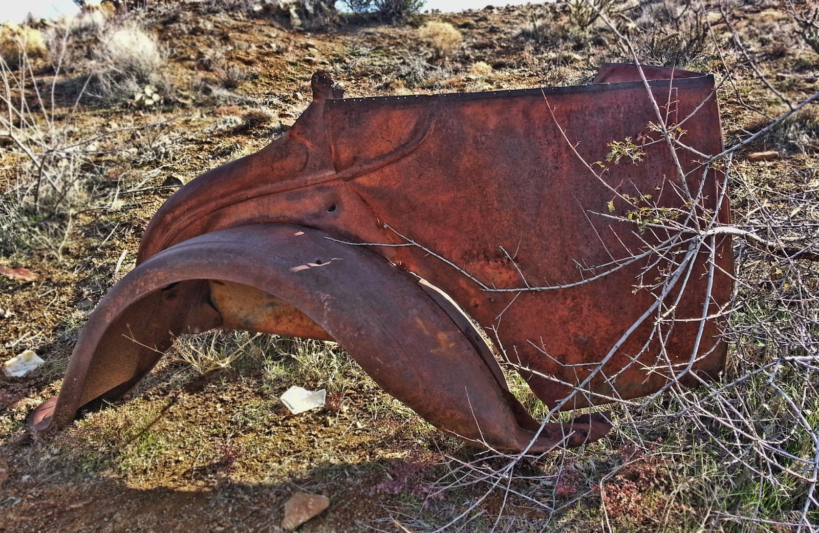
Hi All. Great website. I have been told there is a Model A vehicle on the Richinbar ghost town site? Supposedly this is why the gate is locked to prevent it from being stolen? Have you ever been to this ghost town and seen a model A vehicle? How far of a walk in there is it. Thanks in advance if you know.
Hi... I'm not real good at old vehicles but there is part of the framework of what could be a model A vehicle. Included is a phone photo of what I have found in the past and Ill let you decide what it is. Its one mile easy walk from the locked gate to the site. Sorry for the late response, been out of state. Mark
Would you two be willing to tell me where some of these apple orchards are that you discuss? Thank you for all the info.
A ... Hi... There are numerous abandoned apple and fruit orchards scattered around the Bradshaws Mountains. We are glad to share two sites with you. They are quite well known so I'm sure we wont make very many people upset.
The first one is near Lynx Lake at the trail head for Seven Mile Gulch, adjacent to the Walker Road.
The second, Kendall Camp has a dozen or so trees and if I remember right one plum tree.
The second, Kendall Camp has a dozen or so trees and if I remember right one plum tree.
Lastly the folks at Palace Station are sometimes glad to share their harvest. ..
Bradshaw apple orchards can have amazing harvests, if they don't freeze out in the spring. We usually notify our readers each year when the apples are ready. Sign up for the updates here.
Bradshaw apple orchards can have amazing harvests, if they don't freeze out in the spring. We usually notify our readers each year when the apples are ready. Sign up for the updates here.
http://bradshawmountains.com/blog_newsletter.htm

Can you suggest a good campground near the Hassayampa river. We have enjoyed looking over your article on the hassayampa river. Thank you.
A ... there are several nice USFS campgrounds near the Hassayampa River along the Wolf Creek road. Be sure to also take the short hike into Wolf Creek Falls. You can access the Hassayampa River from this trail. Have fun.

Wolf Creek Campground.
I would like to take a moment to thank Mr. Quigley with Bradshaw Mountains for the time he has taken to teach me the art of photography. During the tour he taught me the simplest aspects of photography such as the rule of 3's and how the aperture on my camera works. Our last outing was structured around setting up shots. What types of things you want in the shot and what you do not want in the shot. Mark has also showed me the different features on my camera to maximize the potential of my camera. Thank you.

Phone Photo, old car in lower Pine Creek
I was trying to do research on the ghost town of Gillette. I understand it was known as a violent western town . Can you point me in the right direction where to find this information?
A... I would suggest visiting Sharlot Hall Museum. They have an amazing archive and research area. We have a link to their site here. http://bradshawmountains.com/links.htm
Yes it was a violent town. You can read an article that I wrote many years ago on Gillette here.
http://www.mrquigleyphotography.com/articles/gillette.htm
http://www.mrquigleyphotography.com/articles/gillette.htm

Mark quit giving away information on your website. Some of us don't want everyone to know where these places are. STOP.

Mark nice to meet you today. I did go to your website and I am impressed, What a resource! I appreciate the information on the Zonia Mine and Placerita ghost town. We want to purchase some framed wildlife prints for our summer home in Prescott. That dog of yours sure is protective of you and your UTV. Thank you again for the information and connection.
A...,. Yes he can be. Email me back your phone number and I will call.

I figured you guys would know this one. I have always heard that there wild ferrel hogs in the bradshaws. Is this true have you ever seen them or is this false? Thank you for your website.
A... There were years ago near the Blue Hills area of the Bradshaws. But haven't heard anything in a while. I checked with Scott and he also said there have not been any sightings or reports. The EZ Ranch near Cordes Junction is said to have an escapee once in a while.

How do you get around in the Bradshaws. What mode of transportation do you use?
A...My favorite way to explore the Bradshaws is on foot. I like to put on a heavy pack for exercise and go for a hike in new locations or visit old ones. To get to these places for the "hike" I use a 4x4 truck, Toyota Rav 4, Polaris RZR or a Trek mountain bike. You will find that you will enjoy the Bradshaws much more this way as well as stay in good physical condition. At times I will plan camping trips using my RZR and over night backpacking trips into remote areas.
Scott's favorite is horseback riding and hiking. He also uses a state 4x4 PU and a ATV. I hope I helped.

Thank you for your website. Can you tell us what the trail number is for the wolf creek waterfall?
A.... Trail 384. Here is a bit more info on it. Have fun.

Can you send me any information on Packer. It is a ghost town in the Bradshaw's. Thanks and appreciate your site for research.
A... Here you go ... and thanks.
http://www.apcrp.org/PACKER/PACKER_071707.htm
Questions about Cesar our dog, is a common email for us. So we are going to place info here on this subject. There has been much interest in this dog breed since it was used in the Osama Ben Laden raid and other military operations.
Hey I love this website! I have a question. Are you the guy that they say hikes with a Belgian Malinois War Dog? If this is your website how does a person adopt a military war dog? Thank you for your help. I am looking to adopt and any information or personal insight for owning a war dog?

The way this works...., is these Military Working Dogs are offered first to police departments in the USA. If not picked up by a PD then, to screened civilian owners. Our dog specializes in searching for explosives/people as well as patrol and bite/hold. I have been retraining him to find dead deceased wildlife parts instead of bombs and he is doing quite well.
Be aware these are highly trained dogs and need and desire constant attention! Malinois have more drive then any other breed so they need constant activity and tasks. They also are very devoted and protective to usually one handler, but my wife and I switch off, and it has worked well for us...., with this dog. Others may be different. We have had previous experience with bird dogs, police and schutzhund trained dogs, so any of your past experience will help.
If you are a well educated dog lover, you may qualify to adopt one. You might be interested in War Dog history..... I'm going to give you several links to review. Also below is a link to adopting War Dogs. Belgium Malinois is the most common breed now used. AGAIN, don't take this decision lightly as War Dogs are highly trained and skilled animals and again you need to give them constant reinforced training and attention. The military only chooses the few that test out the highest, so they can be "allot of dog". As my wife says of this dog, he is "scary smart". They are trained in dutch and hand commands, as many are trained in Holland for service.
Two interesting behaviors about our dog. He never barked or made sound except for a quite low growl. He does growl louder when he has a-hold of the Michelin Man. As a Seal dog he was required to remain quite at ALL times. This sounds crazy but we have been training him to bark. Another thing he does ...., is after we come back from a hike to the vehicle, he insists on going around the vehicle and sniffing all parts. I was told later this was probably a common routine after a mission, and he is just checking for explosives, making sure its safe for everyone to re-enter the vehicle. I guess I will always be safe in this area, lol.
Sorry for the long email but I hope I helped. I commend you on your desire to adopt a War Dog. Thank you. They have served many of our brave and saved the lives of many, and deserve good homes. When you do, send us a pic of it and tell us a bit about him or her.
Thanks for your comments on our site.


War Dog History
Belgian Malinois Breed info
Belgian Malinois War Dogs and Police Dog Info
http://www.youtube.com/watch?
Note: foreign vid not in English of training exercises with Mals
Note: foreign vid not in English of training exercises with Mals
Adopting a War Dog info.
http://www.
Training the Malinois for Mondio Ring
http://www.youtube.com/watch?v=jnUu0rAyIxI
Training the Malinois for Mondio Ring
http://www.youtube.com/watch?v=jnUu0rAyIxI
A tribute to War Dogs and their Handlers KIA

Cesar working, searching for wildlife bones.
Thank you Mark and Scott for your information on the waterfalls in the Bradshaws. I never knew they existed and appreciate the information. Your right, the rocks at Castle Creek Waterfall are slippery. Can you two recommend any other waterfalls? I live in Prescott. Thank you and hope to meet you two someday.
A... Hi Jim There are actually many waterfalls in the Bradshaws. The problem is they only flow when it rains or snow melt. But let me recommend one close to you in Prescott that flows year around. Its a bit different, as far as a traditional waterfall is concerned. Below Watson Lake Dam is a waterfall created by releasing water from the lake. The area below the dam is riparian and is spectacular. You can access this area via a short easy hiking trail off Hwy 89 and East Granite Dells Road . Included is a photo of the falls.
Another beautiful secluded waterfall is up Poland Creek near Crown King but requires a several mile hike into Poland Creek via Algonquin Trail #22. Plan for an all day hike even though many guides say 1/2 day. Here is a link to this know waterfall. Ill email you some photos of it later when I find them.
Ill give you one more that you can do a little digging into. A remote hike up Dead Cow Creek on the east side of the Bradshaws will take you to a waterfall that flows during rain or snow melt. I have some old 6x7 transparencies of it but will take a time to find them also. Ill send you a photo when I do. Have fun and be safe... Reminder don't hike to these places alone.
Lastly here is a fun link of kayakers that use Poland Creek when it flows. Note... We are NOT recommending this but thought you might find it interesting.
Lastly here is a fun link of kayakers that use Poland Creek when it flows. Note... We are NOT recommending this but thought you might find it interesting.


Mark not only did you teach me photography but you were a very patient and considerate teacher. Mark has an artistic flair and concentrates on details and helps make the complex simple for others. If you are considering the art of photography with a good teacher I would highly recommend Mark and Bradshaw Mountains.com. Now I feel I have a good grasp on photography and Ive been able to work with several professional organizations and have made money with something I really love doing.


Prescott Courthouse. Phone Photo by Tom Houtz
Where can I get the new Bradshaw Mountains window decal for vehicles?
A.... Just send us an email and we will drop one in the mail, or they are for sale at some of our partner business. Cost is $6.85 and this includes shipping.
Hi Bradshaw Mountains.com Can someone there tell me if there are trout in any of the streams in the Bradshaws? I have heard rumors.
A... Yes Brad there are trout is some Bradshaw streams. I was privileged to help make recommendations to have them reintroduced and participated in the initial Apache trout stocking into a remote stream. They are currently closed to fishing. Sorry at this time I cant divulge the location/information. I will tell you that I have enjoyed hiking into W Clear Creek and catching wild rainbows and browns. If you go plan to stay a few days, as its worth it. Here is a old photo of a rainbow from W. Clear.
A... Yes Brad there are trout is some Bradshaw streams. I was privileged to help make recommendations to have them reintroduced and participated in the initial Apache trout stocking into a remote stream. They are currently closed to fishing. Sorry at this time I cant divulge the location/information. I will tell you that I have enjoyed hiking into W Clear Creek and catching wild rainbows and browns. If you go plan to stay a few days, as its worth it. Here is a old photo of a rainbow from W. Clear.


The original Apache Trout stocking above in the Bradshaws.
Rainbow from W. Clear Creek.
Thank you for your website on the Bradshaw Mountains! I love to visit and explore them. You have a photo on your website named Hassayampa Hole. Is that a mine in rock? Appreciate you all.
A... Your welcome .... and thank you for emailing us. Hassayampa Hole is just a name I have given this place and it may be known by other names. Most people don't know where it is at and one needs to walk to it. As far as I know it is not a mine but instead a natural weird formation that the Hassayampa River had carved out, after many years. But that's my guess. Thanks.....

Hassayampa Hole
Thank you Mark and Scott for your website. I have a question. Is there a trail that leads below the Lynx Lake Dam? Can I go below the dam?
A... Yes... you can hike below the dam at Lynx Lake. The only dam that I know that is off limits is Willow Lake. There really is no official trail but you can get to Lynx Creek by using the parking lot indicated on the Google Track I am including in this email. I'm also sending you a photo of what the area looks like. Be safe.

Guys I wanted to email and say thanks for the information on Castle Hot Springs. We went to it the other day and found that it is closed to the public. After I returned I found your website and photos and history. Looks like you gained access to the grounds.
A... Thank you ... and feel free to email us any time you have a question. For many years I worked at Lake Pleasant and surrounding area, and the care takers would allow me to wander around. My in laws have owned a home about 2 miles north of Castle Hot Springs for about 48 years now. Because they were neighbors we were invited by.. Someday we hope to see it reopen again to the public. Keep getting out...
Castle Hot Springs Link...

Hello Mark I appreciate that you are willing to share information on the mountain range that you live in. Id love to see other people develop websites on locations around Arizona. Local people always seem to have the best knowledge of where they grew up.
Question if you are willing to answer?
I have always heard there is an unusual duck like petrogliph somewhere on the Aguafria Monument. First again if you are willing to answer, is there such a rock drawing and could you point me in the general direction. God bless you. ....
Hi ... Thank you for your comments. Actually Id like to see other people create websites also on areas they live in. Yes there is a fabled and unusual duck like creature located at only two locations within the Agua Fria Monument. At least as far as I know. Try looking around the Baby Ruin complex and the Richinbar ruin. This and the foot are the two unusual pieces of rock art on the Monument. Send us a photo when you find it, so we can tell if you located both. Good luck and have fun. Petroglyph is spelled ... Petroglyph just for you information.

Hey Guys where is a good place to see turkeys in the Bradshaws? How can I find what they call a roost tree? Thank you for your help. Figured you all would know.
A... Not to many years ago there were no turkeys in the Bradshaws. Before the long time game warden Don Buckley retired he wanted to reintroduce turkeys once again in these mountains. Today you can find turkeys in many locations and the population continues to expand. For locations look near the YMCA camp along the Senator Highway. Try south west of Groom Creek off the Wolf Creek road. Five corners and the old Dandrea Ranch site, are good locations.
Now roost trees. Turkeys in the Bradshaws seem to prefer roosting in ponderosa pine trees, on north facing slopes or canyons. These trees will be located in more remote locations and will require hiking into such habitats. The tell tale sign of a roost tree is the scat underneath such trees. You will also find feathers if the wind has not blown them away. I am sending you a photo of what turkey scat looks like under a roost tree in the Bradshaws. Good luck with your search.

AZGFD turkey release.

Turkeys near the Cash Mine, central Bradshaws.

Love your website.Been living in Prescott for two year. Love this area. Two questions---Cowtown,I know its private property---where exactly is it? So much like an old west town it appears.Never heard of it---any history? Have looked on many maps with no luck.The Poland tunnel to Walker---is it safe to visit? Can you walk the cave to Walker? Love hiking the Bradshaws...thanks for any info you can give me on these 2 questions ...
A... Hi ... Cowtown sits on the river right side of the Agua Fria River below Lake Pleasant. It was built by Ron Nix a Hollywood stunt man in the late 70's. Myself and my friend Brian decided to pay the town a visit after it was complete and we met Ron. He gave us a personal tour of his new town. Many feature films and commercials have been made there, over the years. Ron created a "stunt school" at Cowtown. In recent years it has fallen into disrepair and has been through several owners over the years. Today it actually looks like a ghost town form the old west. Cowtown is private property.
Walker tunnel. Around 1930 the tunnel caved in. It was always plagued with water problems, filling it constantly. Today it's a spring fed hole in the ground and you can visit near the the community of Breezy Pines. Visit our "Poland Road page" for directions. The Walker side is to hard to describe where to find and is also caved in. Was an amazing tunnel for its day. I'm sending you a link to our partner website where you can learn more about the tunnel.
http://www.apcrp.org/POLAND/Poland_Mast_II.htm


Cowtown
Hi Mark and Scott Thank you for this great website. Ive used much of the information to help me explore because I am new to AZ. Can you tell me what kind of maps you use before you explore a new area and recommend one.
A... Hi ... Ive been issued many different maps through the years by the state and personally purchased and tried numerous others. I use different maps for different uses. For searching for old ghost towns or mines I've bought old maps from Sharlot Hall Museum, or if I am looking for a wildlife habitat Ill use a topo 7.5 to evaluate areas. But with the technology available today, I almost specifically use Google Earth to look over an area, that I have never been to before. I also use Earth to go back to specific locations that I have visited before but not found what I was after. I've gotten pretty good at comparing what I see on the computer to what I've actually experienced on the ground.
It sounds like you are a hiker new to AZ, so first think about getting an Arizona Atlas & Gazetteer for general exploring of AZ and a USFS map of specific forests. Use topo maps provided on the web to get down closer and for hiking the Bradshaw Mountains use the National Geographic map.
Lastly I don't even use GPS much anymore partly because I'm pretty use to the Bradshaws but instead I utilize my smart phone and mapping apps. I like Google tracks. It has been around awhile and I'm use to it, and its been the most reliable. Don't get me wrong I still carry and use a compass and GPS. Tracks is good for following your "tracks", which provides you data after the hike. I've tried and used other apps and here as of 2012 are a few I can recommend to you. App technology is constantly changing so I may choose better options in the future.
- Alpine Quest
- Trip Journal (getting old now)
- Back Country Navigator Pro
- My Topo Maps by Trimble Outdoors
- Google Tracks
I hope I've helped and welcome to AZ!
 Bradshaws.
Hi Mark We saw a black rattle snake the other day and my husband said I should email you at this website. It had yellow spots on its back. Do you know what kind of snake it was and have you ever seen anyone bitten by a rattle snake and what happened if you have? Thank you for your help and website! My husband loves it.
A... Hi Susan What you saw was probably a AZ Black Rattle Snake. If you were in higher elevations in the Bradshaws this would fit. The young juveniles are more grey in color and born in mid summer but as they age they become, dark brown to almost a black. They have crossbars that can be white to yellowish in color and can appear to be spots at times. They are venomous with potent hemorrhagic toxins.
As for your snakebite question I have been involved and assisted in three snakebite cases during my career. All were diamondback rattlesnakes and all three people were messing with the snake. Two had actually caught the snake and were also intoxicated so their judgement was a bit off, I guess you could say. All survived and described the bite as "very painful". I visited one of the snakebite victims in the hospital and his hand was swollen badly where he had been bitten. He had actually been bitten twice before throwing the snake back to the ground. About 8000 people a year are bitten by venomous snakes in the USA but few die.
Educate yourself about snakebite and most (not all) of the time a rattler will warn people they are getting near with the tell tale "rattle" signal. Give them a wide birth and continue on. There are wet bites and dry bites.
If you worry about snakebite or hike in areas where snakes are numerous like mid to lower Turkey Creek consider snake gadders. I invested in them years ago as most of my hiking is alone, off trail and in remote areas. I settled on the TurtleSkin brand but there are many to choose from. TurtleSkins are the most expensive but also the most comfortable. I always thought this is one area I didn't want to skimp on. I have done allot of hiking in the Bradshaws with most of it off trail, for many years and have never been bitten. I hope I helped ....
If you worry about snakebite or hike in areas where snakes are numerous like mid to lower Turkey Creek consider snake gadders. I invested in them years ago as most of my hiking is alone, off trail and in remote areas. I settled on the TurtleSkin brand but there are many to choose from. TurtleSkins are the most expensive but also the most comfortable. I always thought this is one area I didn't want to skimp on. I have done allot of hiking in the Bradshaws with most of it off trail, for many years and have never been bitten. I hope I helped ....


Hi Mark I wanted to say thank you for your beautiful photographic website. I appreciate your words and advice on camera brands and was surprised to learn so much about phone photography. I belong to a camera club that is always pushing and proud of their expensive cameras and lens and tripods. When I brought up your website information about photography I was quickly put in my place. Dont get me wrong I learn allot from my club members but it always seems to be about brand and expense. Not how much they saved but how much it actually cost them and they are proud of it! With that said, I had a question. I am on a limited budget and want to buy an all around lens for my brand of camera to be unknown LOL. Can you recommend a good quality lens that will work for almost all situations? By the way I bought your book and love it. Thank you again for all your help.
A... Hi ....For your lens question. I recommend this lens to many people. I also use it and own several. Tamron 18 to 270. It is made for most camera crop sensor bodies. I'm assuming you are not using a full frame camera. Independent tests attest to its sharpness. The only thing I don't like, is over time, in dusty environments it will pick up dust inside, and will need to be cleaned professionally. This is one area where professional lens are better as they are built to tighter tolerances. Its image stabilizing is solid.
If you look at the 2012 Ruger Firearm ads in different shooting magazines, this is the lens I used to create that image. Keep shooting and make your good images into prints, frame them and give them to others as gifts, to encourage and put a smile on their face. Maybe even add a saying that would fit the moment for them and place it on the image.
If you look at the 2012 Ruger Firearm ads in different shooting magazines, this is the lens I used to create that image. Keep shooting and make your good images into prints, frame them and give them to others as gifts, to encourage and put a smile on their face. Maybe even add a saying that would fit the moment for them and place it on the image.
Don't worry about what some of your camera club people say. Not all in your club are that way Im sure. In some cases its just their way of saying "I'm better then you" so they can feel better about themselves. Stay focused (pun intended) and you can learn from everyone there, as every photographer develops their personal style. Your key is to develop an eye and see how the camera sees, and become good at making stunning images. Learn all you can by reading and looking at books and magazines and create your own independent style...

Hi I understand there is an old Flume along Lynx Creek somewhere? You you know where it is at? THX
A... Yes go to Fain Lake Park and walk up-stream . You will find it on river left, above the stream bed.

Can you recommend a place to see geese in the Bradshaw Mountains?
A.... Yes try Willow Lake.

Can you tell us if our Honda CRV can make the trip from Lake Pleasant to Crown King? Its a 4x4. thank you. Great site.
A... the answer is NO. Don't attempt it. Instead take the Bumble Bee route for this vehicle. Here is a link and enjoy your trip.
http://bradshawmountains.com/crown_king.htm

Lake Pleasant to Crown King Rd.
Ive heard there is a old dam on one of the washes above Lake Pleasant. Do you know if there is such a dam and where it is if there is? Also can we drive a 4 four wheel drive truck to it? Thank you for your information.
A... Yes there is a old dam from around 1890 commonly referred to as China Dam. I have included a Google Earth image to mark the location. Yes you can drive to it with your vehicle. It is located a couple miles north of Lake Pleasant, just outside the Park boundary, on Humbug Creek. A hole in the center has kept it from silting in. It was used to store water for a high pressure mining operation along Humbug Creek. A flume also can be found that was used to transport water to mining operations downstream.

China Dam

Thank you Bradshaw Mountains.com Having the ability to see beyond what is right in front of you has taken my photography to an entirely different level, with the tips and guidance I have received from you. I have been able to compose my photos in such a way that they seem to come to life. During your teaching I have gained an entirely different perspective. With the help of Mark, now allow my photos to tell a story. Thank you.

Mark since you answered my last email I was hoping to ask another question. Along the creeks we walk in the Bradshaws we see holes dug by some animal. Is this a hole dug by a badger or what could it be? They seem to be along creeks.Thanks again....
A... Hi again .... I'm sending you a photo and I suspect the holes you are seeing are dug by people looking for gold, not an animal. The photo included was taken along Lynx Creek. With gold worth so much in the current economy, its pretty easy to make a $100.00 a day, if you know what you are doing. So what happens .... is modern day miners will locate a good looking spot, usually in a creek that has potential and dig around in and under rocks and trees. They will pan this out with automated systems or, a simple gold pan. If they are finding gold they will continue until it runs out. This can create the holes you are seeing. Until the creek floods or flows again they will remain. If you ever plan to do this remember to be sure the area you want to pan is not "claimed". Ask anytime.

Gold digging holes along Lynx Creek.
Hi I have been researching the past town of Wagoner on the west side of the Bradshaws. I just found your site and have a question. I have not been able to locate the town site. Can you tell me if anything remains. Can you suggest any resources to assist me? Thank you for your help and plan to spend some time looking over your site. Beautiful photos.
A... Not much remains of Wagoner .... The original site is located on the road. I am including a photo so you will have a landmark to look for when your driving the road. Another reference is the town site sat on the banks of Blind Indian Creek. Keep an eye out on the right and and you will see this area just before the Cooper Ranch. You can walk the old town site and find trash, scattered about. The general store was the last remaining building and it was bulldozed and buried.
Neal Du Shane has done an excellent work up on this town, with many old photographs and information. Sorry for the late reply.
Link to Neal's site
http://www.apcrp.org/index.htm
Town site

Wagoner trash
Scott and Mark thank you for your beautiful website. My friends and I use it. I have two questions and Im sure you two will know the answer.
Can we eat the fish in Watson Lake? I had heard that we shouldnt.
Where is a good place to view elk around Prescott? Ive heard people at work discuss at work that there are elk in in our area. I don't want to hunt them just show family and friends. Can you suggest a few locations. Thank you again for your response and informative website.
A... Yes fish from Watson Lake are OK to consume, especially stocked rainbow trout. In the past there have been warnings about consumption due to an upstream Superfund site.
Best bet for elk viewing is early and late at the Yolo ranch HQ meadow, on the west side of the Bradshaws. You can make a quick trip to the Williams area. Drive Bill Williams Mountain Loop early and late during the rut.

Mark I know this area is not in the Bradshaws but I see on your website that you have been obviously spending time on the Agua Fria National Monument. Have you ever been to the ghost town of Brooklyn?
If you have is it worth a visit? Appreciate your photographic work on the monument. Thank you....
A... Hi ... Your in luck I have been there 2 times. I personally think it is worth a visit. The main mine is caved in now and things around this mining camp are spread out a bit. Have a look, its brought me back twice. Thanks ....

Brooklyn


Hi I was wondering if you have been to a big Indian ruin on a hill above Fain Lake?
I understand it has a fence around it and I cannot go through it. Do you know? Thanks....
A.... Yes .... I have and it is now fenced to protect it. You can follow a trail south of Fain Lake uphill and it will circle around to the ruin site. Ill send you a couple of photos in this email. Its worth the short hike. Thanks for your email. ...

Fitzmanurice Ruin protection fence.

Fitzmanurice Ruin
What are the Arcosanti signs along the freeway at Cordes Junction?
A.... Arcosanti is a compact community, of innovative design, that is self sustainable as well as environmentally sound. It is based on the theories and designs of Paolo Soleri. Construction began along the Agua Fria River in the early 1970's. People live in small spaces and have continued to add on to community through the years. Most that live there are volunteers or attending programs. Tours of the facility are conducted each day and they have a beautiful unique gift store, visitor center that supports their work. About 50,000 people visit each year. The food in their restaurant is actually pretty good (buffet style) and of course healthy.
Be aware Arcosanti has a commune/hippie feel to it. If you are tired of Subway or MacDonald's at Cordes Junction, consider something different, and try their restaurant. Follow the signs on a dirt road for about two miles to the facility.
Be aware Arcosanti has a commune/hippie feel to it. If you are tired of Subway or MacDonald's at Cordes Junction, consider something different, and try their restaurant. Follow the signs on a dirt road for about two miles to the facility.


Maybe you guys will know this. Is there a fishing pond in or around Cordes Junction. Does it have large bass in it?
A... It may have at one time but as I remember fishing was not permitted. Cordes Junction is also referred to as Cordes Lakes thus the ponds you are referring to. In the town are two large, deep man made ponds. But they have been dry for many years. The only other ponds that we are aware of, are on private ranches along the Agua Fria River. The Agua Fria River is known for having large pools of water but this can change from year to year with flooding.

Two of the Cordes Lakes ponds. .

Pool on the Agua Fria near Cordes Junction.
In my research of stage roads I continue to find references to "The Phoenix to Prescott Toll Road." Do you know anything about this road?
Yes in 1890 several Phoenix businessmen invested capital to construct a new stage/wagon road from (now) Lake Pleasant, through the southwest Bradshaw Basin. In the old west toll roads were common. The road you are asking about created a shorter route to Prescott. A toll booth was located near today's Castle Creek bridge, at Lake Pleasant Park. Here a man named Buster Gilbert collected fees and rented extra mules/horses. It followed much of today's Cow Creek road. Many think this is today's Lake Pleasant to Crown King route commonly used by ATVs, and it is not. It instead travels more westward through Ryland Gulch and intersects FS 62. At that point it went down to Campbells Flat and finally connected existing stage roads in Kirkland Junction. It further serviced places in the Bradshaws that were booming, like Wagoner, Walnut Grove and others. If you search for an old state highway map and "I think" the 1967 year, this old road still mistakenly appeared on the map. You can follow this route today with a high clearance 4x4 or ATV and see old stage stop locations and quality road stone work, that still holds much of this road together today. In the spring the road can wash out at Ryland Gulch.

Castle Creek Bridge, low water time of year.

Cow Creek Road Sunset. Lake Pleasant in background.
We receive emails asking for locations for additional Indian Ruins and other cultural resources in and around the Bradshaws. Please understand unless we know you or if you join one of our tours, we do not give away sensitive resource locations. Below is an example why.

Defaced Indian Petroglyph Site. Because of the words painted on others at this site, we cannot even show a photograph.
Gentlemen Thank you for your restaurant suggestions on the site. They are very good and I like good food and out of the way cafes!! I have one for you all. Its in downtown Mayer called Big Bug Station. The best! Another is The Brewery in Prescott. Thanks for this site.
A... Yes we agree, this is a good one in Mayer! They are located in an old historic building with a quaint atmosphere and a bakery. The sour dough bread is made daily. But they are not open on weekends and a bit out of the way. Thanks.
http://bradshawmountains.com/our_partners.htm
Hello I live in Wales (UK) but originate from the North of England. I have been researching my family history and have discovered your wonderful website. The name Bradshaws have its origin in the north of England. I am interested in any historical information there is about William and Isaac Bradshaw. Thank you and hope to visit your mountains one day.
Regards Chris Bradshaw
A.... This answer is from Neal Du Shane founder of APCRP.
Mark with Bradshaw Mountains.com forwarded this email and I hope I can shed some light on your question.
The Arizona Pioneer & Cemetery Research Project (APCRP) has completed some research on the legendary Bradshaw Brothers, Isaac and William, more on Isaac. We can tell you the Bradshaw Mountains were named for them as well as Bradshaw City (ghost town) near Crown King, AZ. Also named for them is Bradshaw Spring near where Isaac is buried. You can visit our website and the restoration/preservation at Isaac's final resting place.
Both brothers were well known prospectors, frontiersmen, and miners.
William was in Lapaz or Ehrenburg (I believe one of the two) on the Colorado River and allegedly met his demise by self inflecting wound with a draw knife to his neck.

Isaac Bradshaw grave.
Photo by Bruce Colbert.
Mark I stumbled upon your beautiful website while searching for information on war dogs. You live in a beautiful part of Arizona. I have always pictured Arizona as a desert state.
I find war dogs fascinating. Its interesting to see how they have been used in civilian life. I found it fascinating to learn that you have retrained your malinois to find wildlife bones. This was new information for me and has prompted a question. When you have a moment I look forward to a response. Has your military working dog ever found human remains? Thank you
Hi ...
The emails and questions about Cesar have caught us a bit off guard. There is allot of interest out there in war dogs and the movie Seal Team Six and others have created even more.
To answer your question.... I think Cesar has no way to distinguish between the remains of species. No he has never found the remains of a human being. He did catch on fast and exchanged explosive devices for bones when I started initally retraining him. Since his retraining he has found remains as small as birds to large cattle. I would like to discourage him from spending time searching for what turns out to be a cow but I don't know how to teach him differences and don't think I can. But either way it keeps him sharp and gives him a job to do and he really likes it. So I suppose someday he could find the remains of a human.
You should consider getting on the War Dog Adoption list with all the interest you have in the breed. Thx. Mark

 Ugly Mountains
..... Also a related question on ruins in the area, as I know you and I share a passion for the Bradshaws. I have climbed to some ruins at the top of a hill west of Turkey Creek (I think its Turkey Creek anyway) and a few miles south of Bumble Bee. Its always been called the " Spanish Fort" by folks I've talked to but I have no idea of its origins and haven't been able to find anything about it online or in any other history source. Do you know its origins?
The "Spanish Fort" you are referring to is a Hohokam Look Out Fort. I have also heard a few locals refer to it as a "Spanish Fort", incorrectly. This Fort does not appear in any publications, on-line or printed. It is also not on any maps. It is mostly unknown and as you say one must climb to it. The Hohokam culture is believed to have built a series of look out observation points that are connected visually one to another. This one connects to a series that end with a high point one, at the very top of the Bradshaws, near the fire tower look out, in Horse Thief Basin.
One way to tell Forts from Pueblos is the lack of pottery shards around the area. This one has virtually no shards. Ports are also common if they remain. This ruin still has ports remaining in the walls.
Lookouts begin with Black Mesa above Black Canyon City and appear all the way to just above Gap Creek (well north of the Agua Fria National Monument) and west to the Hassayampa River. They seem to be well laid out and connected. At some point in the history of the Hohokam culture they became fearful and constructed a well thought out lookout defence system, throughout their living area.
Notice the lookout ports in the walls below.
I find war dogs fascinating. Its interesting to see how they have been used in civilian life. I found it fascinating to learn that you have retrained your malinois to find wildlife bones. This was new information for me and has prompted a question. When you have a moment I look forward to a response. Has your military working dog ever found human remains? Thank you
Hi ...
The emails and questions about Cesar have caught us a bit off guard. There is allot of interest out there in war dogs and the movie Seal Team Six and others have created even more.
To answer your question.... I think Cesar has no way to distinguish between the remains of species. No he has never found the remains of a human being. He did catch on fast and exchanged explosive devices for bones when I started initally retraining him. Since his retraining he has found remains as small as birds to large cattle. I would like to discourage him from spending time searching for what turns out to be a cow but I don't know how to teach him differences and don't think I can. But either way it keeps him sharp and gives him a job to do and he really likes it. So I suppose someday he could find the remains of a human.
You should consider getting on the War Dog Adoption list with all the interest you have in the breed. Thx. Mark
Cattle remains. Phone pic.
Dude dont you know the Bradshaws are a ugly ugly bunch of mountains?
Thank you ..... for letting us know. Mark
..... Also a related question on ruins in the area, as I know you and I share a passion for the Bradshaws. I have climbed to some ruins at the top of a hill west of Turkey Creek (I think its Turkey Creek anyway) and a few miles south of Bumble Bee. Its always been called the " Spanish Fort" by folks I've talked to but I have no idea of its origins and haven't been able to find anything about it online or in any other history source. Do you know its origins?
The "Spanish Fort" you are referring to is a Hohokam Look Out Fort. I have also heard a few locals refer to it as a "Spanish Fort", incorrectly. This Fort does not appear in any publications, on-line or printed. It is also not on any maps. It is mostly unknown and as you say one must climb to it. The Hohokam culture is believed to have built a series of look out observation points that are connected visually one to another. This one connects to a series that end with a high point one, at the very top of the Bradshaws, near the fire tower look out, in Horse Thief Basin.
One way to tell Forts from Pueblos is the lack of pottery shards around the area. This one has virtually no shards. Ports are also common if they remain. This ruin still has ports remaining in the walls.
Lookouts begin with Black Mesa above Black Canyon City and appear all the way to just above Gap Creek (well north of the Agua Fria National Monument) and west to the Hassayampa River. They seem to be well laid out and connected. At some point in the history of the Hohokam culture they became fearful and constructed a well thought out lookout defence system, throughout their living area.
Notice the lookout ports in the walls below.


Spanish Fort is actually a Hohokam lookout fort.
You should be ashamed of yourself promoting adopting military dogs. They have been trained to be war mongers like their human counterparts. There was an important reason why they were unithized instead of adopted to inhumane individuals like yourself. This was one of the worst decisions President Clinton made during his term! And how disgraceful to train a dog to find other animals that are resting in peace. I will be telling everyone how horrible your website is.
Thank you .... for your email. .....I personally think President Clinton and congress made a very good decision by allowing the public to adopt MWD's instead of continuing to kill them after their service was complete. The "inhumane" as you say part of the governments decision, was why did they allow this bad decision to become policy in the first place. These were perfectly healthy well trained animals that served humans well and saved lives. They killed allot of good animals (MWD's) for many years for a very bad reason. In fact probably no reason. I would think this would outrage you. But I'm guessing you will disagree.
I further disagree on this being his "worst decision" and think President Clinton made a very bad decision in another area that still haunts him today but, ... don't want go there.

Kill the MWD's after they complete their service.
Hi Can you tell us what a trick tank is? Thank you for your informative website.
Hi.... A Trick Tank is a water collection system that holds water in a large tank and dispenses it on demand into a basin where wildlife drink from it. There are many different styles but the most common in the Bradshaw Mountain Range is an inverted umbrella constructed of either asphalt or cement which collects the water during rainy periods. Trick Tanks have fenced exclosures to keep cattle out. They are almost exclusively designed for wildlife in more arid areas. On Google Earth they sick out like a soar thumb once you know what you are looking for. Hope I helped.

Trick Tank south of Blue Bell Mine.

Hi I love this website! You should write a book with all the information you probably have in your mind. I have a question. I have been told that there are a few dams along Lynx Creek that require walking to. But I dont know how reliable this information is and it sounds like fun to look for them.
Can you help? Thank you. ....
Hi ..... Thank you for your complement.
There are several dams on Lynx Creek and actually on many creeks throughout the Bradshaw Mountains. But I think you may be asking about the smaller ones. The big dams along this creek are Lynx Lake are Fain Lake. But many other dams were built along this drainage system. They were all used to collect and hold water for mining and drinking purposes. Many have flume or canal systems that moved water downstream. The water was forced into small hose systems that aided miners to quickly wash away the banks of creeks in search for gold.
Off the top of my head there are 8 smaller dams along Lynx Creek besides Fain and Lynx Lake. Many are silted in now while others are broken usually in the middle. In years past these dams were know to be unstable and burst at times. One that created a nice lake above the town of Mayer broke and flooded the town in the late 1800's. Another along the Hassayampa River is still considered to be Arizona's worst disaster, after it burst and killed many people downstream, and flooding Wickenburg. You can hike to many of these today. Probably the best stretch would be to park at the Lynx Lake boat launching parking lot, and follow the creek upstream. About 1/2 mile is a fairly large silted in dam. Within two more miles from it are several smaller dams. Have fun searching for them.

Fain Lake Dam

Dam 1/2 mile above Lynx Lake.

Dam couple of miles above Lynx Lake.

Burst dam several miles above Lynx Lake.
Can you tell us where Cedar Tank is? I see a link on your website but it is a dead link. Ive never heard of this tank. Thank you for your help. Great site. Love the pics and they help us make decisions where to go next.
Hi .... I'm sorry yes the link is "dead" for Cedar Tank. I have been waiting for it to completely fill again and plan to re photograph it. It is also referred to as Cedar Tank Wildlife Area and is located about 5 miles west of Mayer on the Pine Flat Road. Refer to an Arizona Gazetteer as it is shown on this map. It does not appear on many other maps. Years ago when it was full it held some very large bluegill and bass. It is a very large tank when full.

Cedar Tank.

Cedar Tank.
Bradshaw Mountains I wanted to say thankyou for publishing your favorite hikes. I have found them to be some of the best hikes ever! I wanted to encourage everyone there to put up more. I especially like the offtrail as you call them.
I have a question. Can you recommend any other hiking areas along or near interstate 17 similar to the Badger creek hike into the Ague fria?
I knew absolutely nothing about war dogs until reading this website and I must say it is an unusual place to be educated on such an interesting subject. Keep up the good work everyone and thank you. Fellow hiker....
Your welcome Fellow Hiker! We have been encouraged by some of the emails thanking us for our hikes. Sometimes when you put up, out of the ordinary hiking locations, your not sure how well they will be received.
Now your really forcing us to give up a real gem here, that is located adjacent to I 17. This hike is not in the Bradshaw Mountains and there is no trail. It is an "off trail" hike that simply follows a dry wash that turns into a small flowing stream filled with fish and connects with another, named Little Ash Creek. The name of the drainage is Ash Creek. The riparian forest is amazing, as well as wildlife viewing opportunities. A few rock art / chipping sites can found if you have experience in locating these types of sites. It is open range so expect to see cattle / horse disturbance and watch for rattle snakes. Snakes hide in the taller grasses here. I am including a Google Map to follow. Take the Dugas exit off I 17 and turn east for about 1/4 mile. Turn right and follow a dirt road (on map) to the starting point. Don't attempt this hike during rainy periods (flooding) This dirt road turns to slick deep mud. There are two ways back to the vehicle.... . If you take the short cut it will shave off about 2 miles.
So this little gem of a hike is between 8 and 10 miles. Of course you can turn around at any time and return the way you came. Let us know what you think of it .... and send us a pic. Enjoy.


Google Map
https://maps.google.com/maps/
Mark I'm glad to have found your website. My question is, I understand there is a rental cabin within Horse Thief Basin. I have not been able to find information for it. Do you know if there is such a cabin and if it is still around or possibly it burned during the fire of 2012. Thank you for your help. ....
.... here you go. Yes the rental cabin is still around. Another cabin at Towers Mountain is no longer being rented. Both survived the Gladiator fire. Enjoy. Mark
http://www.reserveamerica.com/camping/Horse_Thief/r/campgroundDetails.do?contractCode=NRSO&parkId=74085

Photo by Reserve America.com
Hi Mark I have one question. When I pass by Lynx Lake on the Walker road is a sign that says Highland Center. If I'm not watching closely for it, it can be easily missed. Do you know what this is? Thanks for your informative website on the Bradshaws! ....
Hi ... We have received several emails similar to yours so your not the only one who asks. I am attaching information from their website below. It is open to the public.
The Highlands Center for Natural History is a non-profit science and ecological education organization located in Prescott, Arizona.
OUR MISSION
The Highlands Center helps children and adults discover the wonders of nature and become wise caretakers of the land. We believe that everyone has a fundamental need to connect with the natural world. This connection is fostered by the Center through outdoor-science education based on observation and discovery of the Central Arizona Highlands.

Hi ...
No I did not see it but another person told me about it recently. I appreciate the email.
He is 7 years old. He was injured in the back left leg by an explosion or bullet wound. The Navy labels the incident as "classified" and would not disclose any information about the injury. Our vet speculates on the injury. Thanks for letting me know....
Click link below to see the story on Dogs of War.
http://www.cbsnews.com/video/watch/?id=50145334n

60 Minutes Photo
Guys I notice the areas and hikes you recommend are often in remote and inaccessible areas. Why don't you publish information on more established trails and well know locations? I look forward to seeing your photographs with each update. They are amazing. ...
If someone is wanting a more rugged, remote experience where one has an opportunity to observe wildlife and less know scenic locations, we make them available here through Bradshaw Mountains.com.
With that being said we will make a concerted effort to put up a few more well know areas. Thank you for your complement on our images.

Watson Wood Preserve, a heavily used area near Prescott. An exceptional well maintained trail system wanders throughout the Preserve. Less visited during early mornings and colder times of the year.
Hello My jeep club is planning a trip to the Bradshaw's. We are considering taking the Bannie Mine rd south of Lynx Lake all the way to Dewey. Do you know if this road is passable? Cool dog. ....
If you desire another rough road take FS 9270N out which connects with the Poland Road. Don't forget to stop by the McCabe cemetery. There are plenty of mines and tanks along the way. Most of the mines on this side of the Bradshaws are from the 1900's according to most of the old dump piles Ive gone through. Almost all are deep holes in the ground so be careful. A couple of unknown Indian ruins in the area also. Have fun and be safe.

Bannie Mine Road in Chaparral Gulch.

Union

Mines in the area.

FS 9270 Road.

Old wagon wheel near the Bannie Mine Road.
Click your BACK arrow now to return to website or link below.

--
"Explore the Mountains"
Visit our website...
Bradshaw Mountains.com